
The uranium deposits of northern Arizona are hosted by unusual geologic features described as "solution-collapse breccia pipes", or simply "breccia pipes". The region surrounding the Grand Canyon hosts hundreds, possibly thousands, of breccia pipes that were formed by solution and collapse. Breccia refers to the broken rock that fills these features, and pipe refers to the vertical, pipe-like shape of these features. Some of these breccia pipes contain concentrated deposits of uranium, arsenic, copper, silver, lead, zinc, cobalt, and nickel minerals1. Exploration in the region has shown that a small percentage of the identified breccia pipes do contain economic uranium deposits. The USGS has mapped about 300 breccia pipes in the northern Arizona region and more than 1,100 additional collapse features that may overlie breccia pipes.
The breccia pipes generally form sequentially by:
Collapse structures that may be potential breccia pipes at depth have not been observed in rock units younger than Triassic age (see geologic cross section, click to enlarge cross section). The breccia fragments that form the pipes are consistently blocks and pieces of rock units found below their normal position in the wall rock; that is, all rocks within the breccia column (pipe) have fallen downward and are never found above their original level. In contrast to many other types of breccia pipes, there are no igneous rocks associated with the northern Arizona breccia pipes, nor have igneous processes contributed to their formation.
Once geologic, geochemical, and (or) geophysical indicators suggest that a breccia pipe structure exists at a site then exploratory drilling is conducted to test for uranium deposits. Since uranium deposits occur deep inside the pipe, usually several hundred feet below the plateau surface, the only way to determine if a pipe contains uranium is by sampling of the drilled material.
Most of the uranium deposits in the northern Arizona breccia pipes are high in uranium content (high-grade deposits) by U.S. Standards. Breccia pipe deposits mined or drilled during the 1980s revealed average grades of 0.42 to 1.08 percent uranium oxide (U3O8)4,5. These deposits contained about 430,000 pounds to 7 million pounds U3O8. Combined uranium production has totaled 23.3 million pounds of ore (to November 2009), including past production from the Hack 1, Hack 2, Hack 3, Pigeon, Hermit, Kanab North, and Pinenut pipes, plus the Orphan Mine6.
The primary uranium ore mineral in the breccia pipe deposits is uraninite (UO2).
The uranium mineralization is mostly concentrated near the rock units of the Esplanade Sandstone, Hermit Formation, and Coconino Sandstone; these stratigraphic horizons typically lie several hundred feet below the plateau surface in the North, South, and East Parcels. Drilling of the Pinyon Plain (formerly Canyon) pipe by Energy Fuels Nuclear found that uranium minerals extend for more than 1,600 ft vertically down through the breccia pipe7. Earlier studies of breccia pipe mineral deposits by USGS geologist Karen Wenrich identified at least two separate events of mineralizing fluids.
"The main uranium-mineralizing event apparently occurred after deposition of the Triassic Chinle Formation. A large set of U-Pb isotopic analyses from the Hack 1, Hack 2, Kanab North, EZ-1, EZ-2, Arizona 1, Pinenut, and Pinyon Plain (formerly Canyon) pipe orebodies shows that the main uranium-mineralizing event occurred about 200 m.y. [million years] ago; data from Pinyon Plain (formerly Canyon) and Pinenut pipes, however, indicate at least one earlier period of mineralization roughly at 260 Ma . Petrographic studies suggest that uranium mineralization occurred after most of the Co, Cu, Fe, Mo, Ni, Pb, and Zn mineralization; hence, these other metals must have been deposited prior to 200 m.y. ago."
Karen Wenrich, Breccia pipes in the Red Butte area of Kaibab National Forest, Arizona, 1992
Sources:
1 Wenrich, K.J., 1985, Mineralization of breccia pipes in northern Arizona: Economic Geology, v. 80, p. 1722-1735, https://doi.org/10.2113/gsecongeo.80.6.1722
2 Wenrich, K.J., Billingsly, G.H, and Van Gosen, B.S., 1989, The potential of breccia pipes in the National Tank Area, Hualapai Indian Reservation, Arizona: U.S. Geological Survey Bulletin 1683-B, 35 p.
3 Spiering, E.D., 2009, Exploration and discovery of blind breccia pipes-The potential significance to the uranium endowment of the Arizona Strip District, northern Arizona: U2009 Global Uranium Symposium, Keystone, Colo., May 9-13, 2009
4 Pool, T.C., and Ross, D.A., 2007, Technical report on the Arizona strip uranium project, U.S.A.: Scott Wilson Roscoe Postle Associates Inc., prepared for Denison Mines Corp., 116 p.
5 Moreton, Christopher, and Ross, David, 2009, Technical report on the EZ1 and EZ2 breccia pipes, Arizona Strip District, U.S.A.: Scott Wilson Roscoe Postle Associates Inc., prepared for Denison Mines Corp. [variously paged], accessed November 3, 2009
6 Otton, J.K., and Van Gosen, B.S., 2010, Uranium resource availability in breccia pipes in northern Arizona, Chapter A in Alpine, A.E., ed., Hydrological, geological, and biological site characterization of breccia pipe uranium deposits in northern Arizona: U.S. Geological Survey Scientific Investigations Report 2010-5025, p. 23-41
7 Casadevall, W.P., 1989, Exploration geology of Canyon breccia pipe south of Grand Canyon, Arizona [abs.]: American Association of Petroleum Geologists Bulletin, v. 73, no. 9, p. 1150
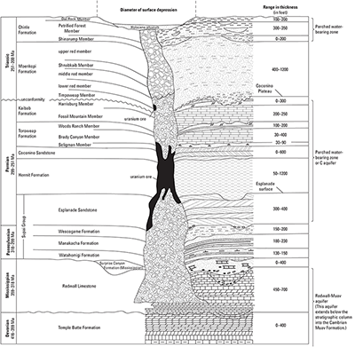
Schematic cross-sectional depiction of a solution-collapse breccia pipe of northern Arizona from Otton, J.K., and Van Gosen, B.S., 2010, Uranium Resource Availability in Breccia Pipes in Northern Arizona: U.S. Geological Survey Scientific Investigations Report 2010-5025, chapter A.
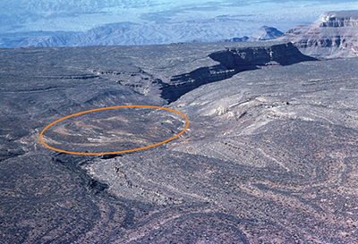
Example of a collapse structure above a breccia pipe. This is the plateau expression of the Grand Pipe, western Grand Canyon near the Colorado River and Grand Wash Cliffs. The collapse structure on the plateau surface measures approximately 2,500 feet in diameter. Note the circular rim of strata dipping inward towards the center of the collapse. Photo taken by George Billingsly, USGS.
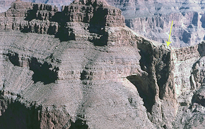
An exposed breccia pipe column (indicated by arrow) in the Grand Canyon area. Note the bending of strata toward the breccia pipe. Photo taken by George Billingsly, USGS.