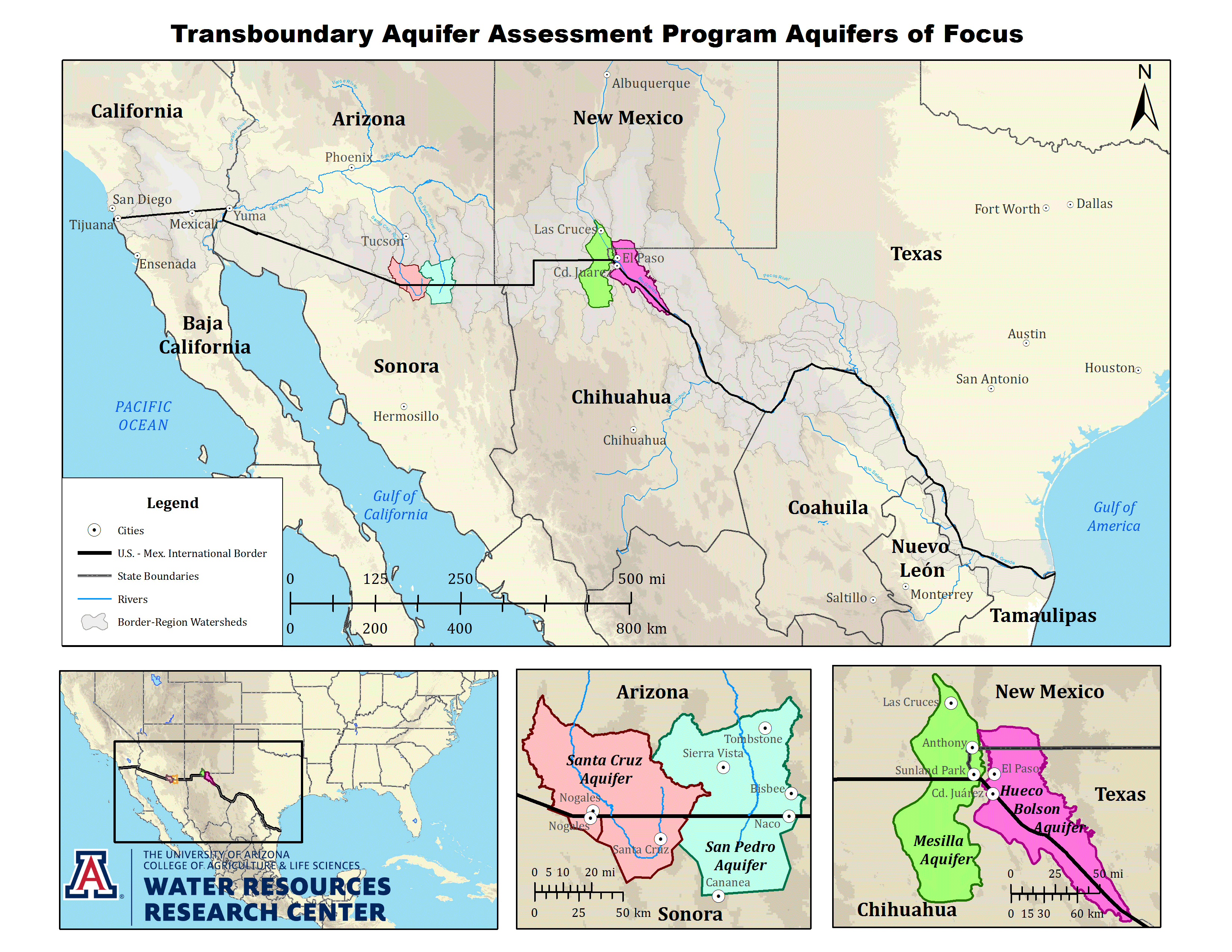
Transboundary Aquifer Assessment Program (TAAP)
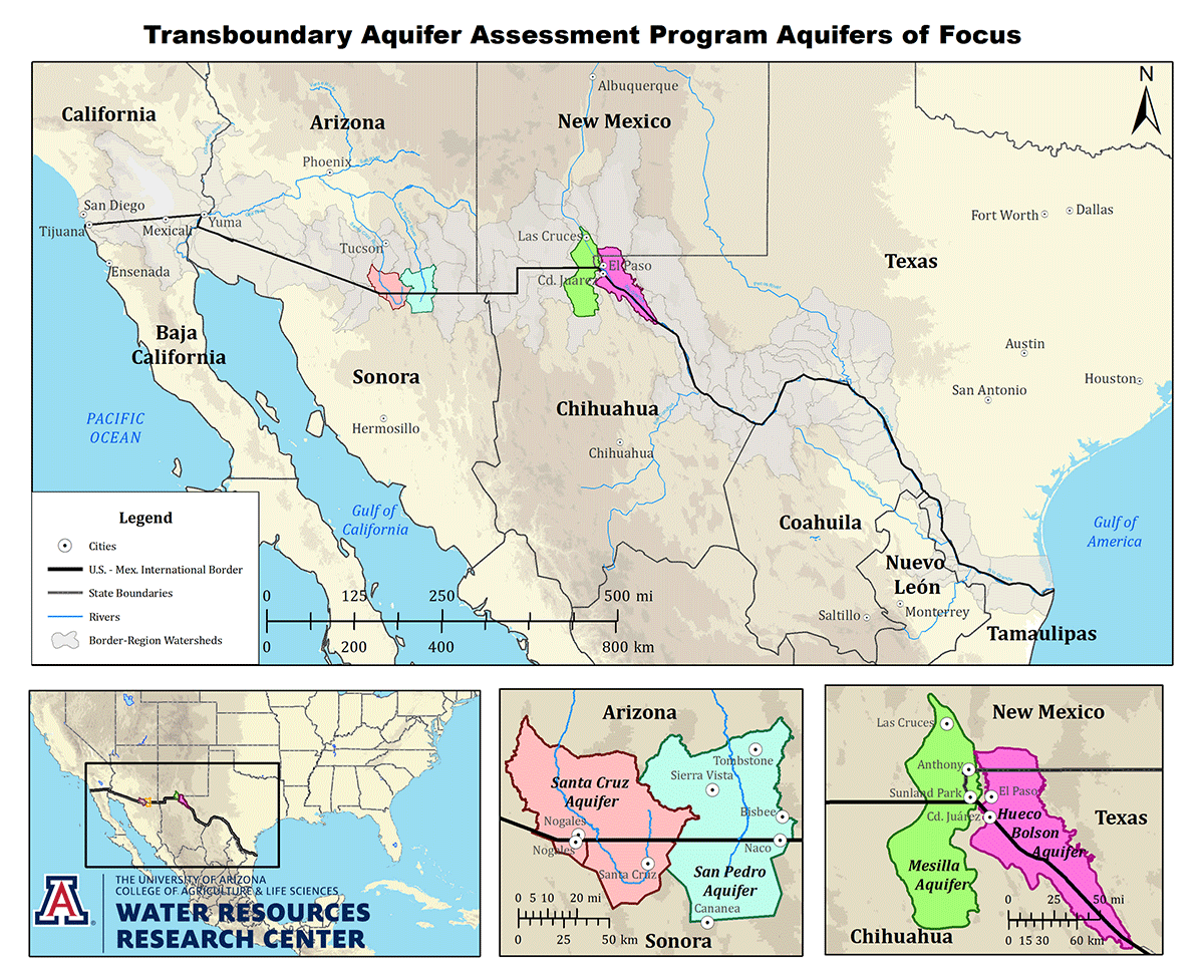
Modified with permission from The University of Arizona, College of Agriculture
& Life Sciences, Water Resources Research Center.
Full Size version (1.7M))
San Pedro
Like other priority aquifers, the Binational San Pedro Basin (BSPB) lies within the Basin and Range physiographic province and is classified as part of the southwest basins alluvial aquifer system (Robson and Banta, 1995; Ryder, 1996). Prior to the TAAP, there was a general lack of hydrologic information on the Mexican side of the aquifer. On the United States side of the border, however, the BSPB was one of the most studied basins in the region, in part because the groundwater-dependent river corridor supports one of the highest diversities of mammals in the United States (84 species), and is one of the major North American flyways for migratory birds, with over 350 species identified to date (Gungle and others, 2016). The river corridor also supports the globally imperiled North American Warm Desert Riparian ecosystem (NatureServe, 2017). As the result of this, the United States side of the San Pedro River and its riparian ecosystem have been designated a National Riparian Conservation Area. The economic drivers on each side of the border are quite different. In the Arizona portion of the basin, military and tourism dominate, while in the Sonoran portion, mining is the most important industry. The basin is home to the U.S. Army Base at Fort Huachuca, which is one of the Army’s main intelligence research and training centers. In addition, the copper deposit near Cananea, Sonora is one of the largest in the world, generating nearly 40% of the copper produced in Mexico (Jiménez, 2014). The BSPB hosts several municipalities with a combined population of about 100,000. Previous studies include topics that range from geophysics and hydrogeology to biology and ecosystem services. Water resources are needed to sustain the river, existing communities, and continued development.
TAAP - Binational Study of the Transboundary San Pedro Aquifer
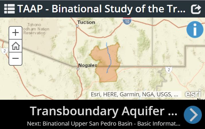
The Binational Study of the Transboundary San Pedro Aquifer is a milestone output of the TAAP. Both countries contributed scientific knowledge and data on climate, geology, soils, land cover, land use, and hydrology. This study compiled and created a database of scientific information and identified data gaps and information to be updated in subsequent phases.
Santa Cruz
The priority designation for the Upper Santa Cruz Aquifer is based on a number of factors, including the recognition that the binational aquifer is an important source of water for the sister cities of Nogales, Arizona and Nogales, Sonora, which have a combined population of about 300,000. The basin is also a regional focus of economic activity. The Nogales area is host to over $300 million annually in industrial activity, and the Nogales Port of Entry is the point of access for more than $16 billion in annual binational trade (Nogales-Santa Cruz County Economic Development Foundation, 2017). A new copper mine, El Pilar, has been permitted, and is waiting for development near the banks of the Santa Cruz River in Sonora. Impaired and contaminated surface and groundwater is documented on the United States side of the border. Because of these actual and potential economic and environmental impacts, there is a long-term need to establish sustainable management of the aquifer for the benefit of both Mexico and the United States. The aquifer also has a high ecological value, because it sustains the Santa Cruz River and associated aquatic and riparian ecosystems. As the result of heavy reliance on groundwater, the portion of the aquifer east and north of Nogales was designated the Santa Cruz Active Management Area (SCAMA) by the state of Arizona, meaning that groundwater use is more strictly monitored and regulated than in other parts of the state.
Mesilla/Conejos-Médanos
The Mesilla Basin is a north-south trending rift basin in southern New Mexico extending through El Paso, Texas into Chihuahua, Mexico. The basin is approximately 2,900 square kilometers (km2), and includes about 500 km2 in Mexico (Hawley and Kennedy, 2004).
The hydrologic boundaries of the Mesilla Basin are a combination of mountain ranges and faults. The Rio Grande is the primary surface-water resource in the Mesilla Basin. The river enters the basin at the end of Seldon Canyon, about 35 km north of Las Cruces, New Mexico and exits through the El Paso Narrows near El Paso, Texas. The total drainage area above the Rio Grande at the El Paso, Texas gage near the El Paso Narrows is about 75,800 km2 (USGS National Water Information System). Groundwater recharge occurs as a combination of mountain-front recharge, inflow from adjacent aquifers, infiltration of water from the Rio Grande, and infiltration of irrigation water (Moyer and others, 2013). Much of the recharge to the groundwater system is thought to occur along the 100-km long Rio Grande channel within the Mesilla Valley (Nickerson and Myers, 1993). The loss of streamflow due to this recharge is reported in several investigations by the USGS (Crilley and others, 2013; Gunn and Roark, 2014; Briody and others 2016a and 2016b). Groundwater generally flows from north to south in the Mesilla Basin (Hawley and Kennedy, 2004).
The conjunctive use of water in the Mesilla Basin takes place under a myriad of legal constraints, including the Rio Grande Compact, an international treaty with Mexico, and a federal water project. Declining water levels, deteriorating water quality, and increasing use of water resources by municipal, industrial, and agricultural water users on both sides of the international border have raised concerns about the long-term availability of the groundwater and surface water supplies in the region (Alley, 2013).
Hueco Bolson
The Hueco Bolson aquifer spans a total area of approximately 6,500 km2 that includes portions of New Mexico and Texas in the United States, and Chihuahua in Mexico (Hutchison and Hibbs, 2008). It is bounded by several mountain ranges - including the Franklin and Sierra Juarez Mountains to the west, the Hueco and Quitman Mountains to the east, and the Sierra El Presidio to the south (Hibbs, 1999; Hutchison and Hibbs, 2008; Sheng, 2005; White, 1983).
Drillers have known that the Hueco Bolson was a good source of water since the late 1800s (Hibbs, 1999), and it has become the main source of fresh groundwater for municipal, military, and industrial use in the transboundary region near El Paso, Texas (White, 1983; White and others, 1997). By the end of the 20th century, the total binational population in the El Paso metropolitan area grew to approximately 2 million (Heywood and Yager, 2003). Although White (1983) observed that earlier population growth led to increased groundwater pumping in the Hueco Bolson, conservation efforts and pricing strategies implemented by El Paso Water led to pumping reductions between the years 1989 and 2005 (Hutchison, 2006). Total groundwater drawdown was observed to exceed 60 m in some areas (Heywood and Yager, 2003), which has led to concerns with brackish water intrusion - in some cases production wells have even been abandoned due to deteriorating water quality (Heywood and Yager, 2003; Hutchison, 2006). Groundwater management in the area is centered on these interrelated issues of declining groundwater levels and brackish groundwater intrusion (Hutchison, 2006). Current management strategies include acquisition of surface water rights by El Paso Water to reduce pumping requirements (Hibbs, 1999), injection of reclaimed wastewater into the aquifer (Sheng, 2005), and the operation of the Kay Bailey Hutchison desalination plant to allow for the use of brackish groundwater resources (Hutchison, 2006; Sheng, 2013).
References:
Alley, W.M., ed., 2013, Five-year interim report of the United States-Mexico Transboundary Aquifer Assessment Program: 2007–2012: U.S. Geological Survey Open-File Report 2013–1059, 31 p. (Available at http://pubs.usgs.gov/of/2013/1059/.)
Briody, A.C., Robertson, A.J., and Thomas, Nicole, 2016a, Seepage investigation of the Rio Grande from below Leasburg Dam, Leasburg, New Mexico, to above American Dam, El Paso, Texas, 2014: U.S. Geological Survey Scientific Investigations Report 2016–5010, 15 p. (Available at http://dx.doi.org/10.3133/sir20165010.)
Briody, A.C., Robertson, A.J., and Thomas, Nicole, 2016b, Seepage investigation of the Rio Grande from below Leasburg Dam, Leasburg, New Mexico, to above American Dam, El Paso, Texas, 2015: U.S. Geological Survey Scientific Investigations Report 2016–5011, 15 p. (Available at http://dx.doi.org/10.3133/sir20165011.)
Crilley, D.M., Matherne, A.M., Thomas, Nicole, and Falk, S.E., 2013, Seepage investigations of the Rio Grande from below Leasburg Dam, Leasburg, New Mexico, to above American Dam, El Paso, Texas, 2006–13: U.S. Geological Survey Open-File Report 2013–1233, 34 p. (Available at http://pubs.usgs.gov/of/2013/1233/.)
Gungle, B., Callegary, J.B., Paretti, N. V., Kennedy, J.R., Eastoe, C.J., Turner, D.S., Dickinson, J.E., Levick, L.R., and Sugg, Z.P., 2016, Hydrological conditions and evaluation of sustainable groundwater use in the Sierra Vista Subwatershed, Upper San Pedro Basin, southeastern Arizona: U.S. Geological Survey Scientific Investigations Report 2016-5114, 90 p. (Available at https://doi.org/10.3133/sir20165114.)
Gunn, M.A., and Roark, D.M., 2014, Seepage investigation on the Rio Grande from below Caballo Reservoir, New Mexico, to El Paso, Texas, 2012: U.S. Geological Survey Scientific Investigations Report 2014–5197, 17 p. (Available at http://dx.doi.org/10.3133/sir20145197.)
Hawley, J.W. and Kennedy, J.F., June 2004, Creation of a digital hydrogeologic framework model of the Mesilla Basin and Southern Jornada Del Muerto Basin: New Mexico Water Resources Research Institute Technical Completion Report 332, 105 p. (Available at https://nmwrri.nmsu.edu/tr332/.)
Heywood, C.E. and Yager, R.M., 2003, Simulated ground-water flow in the Hueco Bolson, and alluvial-basin aquifer system near El Paso, Texas: U.S. Geological Survey Water-Resources Investigations Report 2002-4108, 73 p. (Available at https://pubs.er.usgs.gov/publication/wri024108.)
Hibbs, B.J., 1999, Hydrogeologic and water quality issues along the El Paso/Juarez corridor: an international case study: Environmental and Engineering Geoscience, v. 5, no. 1, p. 27-39.
Hutchison, W.R., 2006, Groundwater management in El Paso, Texas: El Paso, University of Texas at El Paso, Ph.D. dissertation, 329 p.
Hutchison, W.R., and Hibbs, B.J., 2008, Ground water budget analysis and cross-formational leakage in an arid basin: Ground Water, v. 46, no. 3, p. 384-395.
Jiménez, R., 2014, Cananea produce 38% del cobre de México: El Economista.
Moyer, D.L., Anderholm, S.K., Hogan, J.F., Phillips, F.M., Hibbs, B.J., Witcher, J.C., Matherne, A.M., and Falk, S.E., 2013, Knowledge and understanding of dissolved solids in the Rio Grande–San Acacia, New Mexico, to Fort Quitman, Texas, and plan for future studies and monitoring: U.S. Geological Survey Open-File Report 2013-1190, 55 p. (Available at http://pubs.usgs.gov/of/2013/1190/.)
NatureServe, 2017, Ecological System Comprehensive Report: North American Warm Desert Riparian Systems. (Available at http://explorer.natureserve.org/servlet/NatureServe?searchSystemUid=ELEMENT_GLOBAL.2.784842.)
Nickerson, E.L. and Myers, R.G., 1993, Geohydrology of the Mesilla ground-water basin, Dona Ana County, New Mexico and El Paso County, Texas: U.S. Geological Survey Water-Resources Investigations Report 92-4156, 89 p. (Available at https://pubs.er.usgs.gov/publication/wri924156.)
Nogales-Santa Cruz County Economic Development Foundation, 2017, Industry Profile - Economic Impact. (Available at http://nogales.com/industry/economic-impact/.)
Robson, S.G., and Banta, E.R., 1995, Ground Water Atlas of the United States: Segment 2, Arizona, Colorado, New Mexico, Utah, Hydrologic Atlas 730-C. (Available at https://pubs.er.usgs.gov/publication/ha730C.)
Ryder, P.D., 1996, Ground Water Atlas of the United States: Segment 4, Oklahoma, Texas, Hydrologic Atlas 730-E. (Available at https://pubs.er.usgs.gov/publication/ha730E.)
Sheng, Z., 2005, An aquifer storage and recovery system with reclaimed wastewater to preserve native groundwater resources in El Paso, Texas: Journal of Environmental Management, v. 75, p. 367-377.
Sheng, Z., 2013, Impacts of groundwater pumping and climate variability on groundwater availability in the Rio Grande basin: Ecosphere, v. 4, no. 1, p. 1-25.
White, D.E., 1983, Summary of hydrologic information in the El Paso, Texas, area, with emphasis on ground-water studies, 1903-80: U.S. Geological Survey Open-File Report 83-775, 77 p. (Available at https://pubs.er.usgs.gov/publication/ofr83775.)
White, D.E., Baker, E.T, Jr., and Sperka, Roger, 1997, Hydrology of the shallow aquifer and uppermost semiconfined aquifer near El Paso, Texas: U.S. Geological Survey Water–Resources Investigations Report 97-4263, 37 p. (Available at https://pubs.er.usgs.gov/publication/wri974263.)


