Coastal Carolinas Focus Area Study
Methods
Water Use Tasks
Available water-use data from the USGS 5-year water-use compilations for South Carolina and North Carolina (1990-2015), more frequently compiled water-use data by the States, and new approaches will be assessed to evaluate estimated water use and withdrawal trends in the Coastal Carolinas.
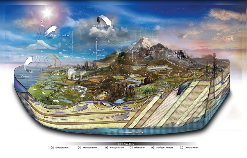
The primary tools that will be developed as part of the CC FAS will be numerical models that will be driven by state-of-the-science input parameters. The inputs to the models will include those parameters that act as “stresses” to the water budgets in the FAS region. Data for multiple water-use categories will be compiled, integrated, spatially distributed and used in the models developed and applied for the CC FAS. Water-use information is independently valuable; however, spatial integration of water-use data with natural-flows data will identify areas of water-supply stress, and help to inform water and ecosystem management efforts.
Study Component Leads
Douglas Smith, Fred Falls, and Jaime Painter
USGS South Atlantic Water Science Center
Sources, Locations, and Use of Withdrawals and Discharges
Improved understanding and estimates of water-use will be one of the most essential outcomes of the CC FAS. By focusing effort on water use, the USGS will be better able to characterize how humans move, utilize, consume, and dispose of the water they withdraw, divert, or impound. Another valuable outcome of the CC FAS will be to integrate that improved information with a better understanding of natural flows in the environment. The approach to complete this study component is as follows:
Update Regional Databases
- Water-use estimates from the 2000 to 2010 USGS water-use compilations will be refined and disaggreated to the watershed HUC-8 level for public supply, industrial, crop irrigation, golf course irrigation, and thermoelectric power generation. The refined water-use estimates will be entered into USGS Aggregated Water-Use Data System (AWUDS).
- Complete the Site-Specific Public Water Use Database System (SWUDS) that will identify public water-supply distribution systems, groundwater and surface-water withdrawal points, and provide information related to the conveyance and ultimate usage (in 2010) of the water withdrawn for public water-supply systems in the CC FAS region.
- Incorporate site-specific return flows (discharge) from municipal and industrial facilities to surface-water bodies (2010) into SWUDS.
Spatial Distribution of Withdrawals and Discharges
- Spatially distribute withdrawals and wastewater discharges to the watershed HUC-8 scale for public supply, domestic, industrial, crop irrigation, golf course irrigation, and thermoelectric power generation for the 2000, 2005, 2010, and 2015 USGS water-use compilations.
- Because of inherent limitations in the available data, only county-wide aggregated water use estimates have been previously developed for crop irrigation, livestock, aquaculture, mining, and domestic water-use categories. The 2000-2015 county-wide aggregated estimates for these categories of water usage will be disaggregated so that all water-use estimates will be reported to the watershed HUC-8 area.