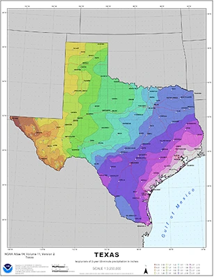
Flooding remains the leading cause of natural-disaster loss across the United States. The Interagency Flood Risk Management (InFRM) team brings together Federal Partners with mission areas of hazard mitigation, emergency management, floodplain management, natural resources management or conservation to leverage the skill sets, resources and programs to determine the needs of communities and define solutions and implement measures to reduce long term flood risk throughout the States of Arkansas, Louisiana, New Mexico, Oklahoma and Texas.
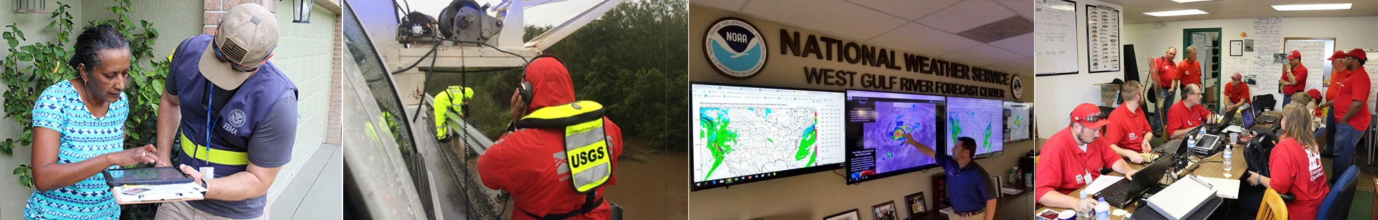
In 2014, the Federal Emergency Management Agency (FEMA) began sponsorship of the InFRM team initiative to allow Federal teams across the States of Texas, Oklahoma, New Mexico, Louisiana and Arkansas to better align and integrate. Currently, the InFRM team is comprised of FEMA, US Army Corps of Engineers, US Geological Survey, and the National Weather Service. No single agency has all the answers, but through a coordinated effort of multiple programs and various perspectives, a cohesive solution can be found. By applying their shared knowledge, the InFRM team can also enhance response and recovery efforts when flood events do occur.
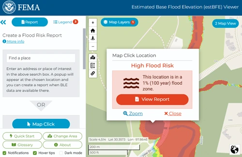
While floods are impossible to prevent completely, and there is no way to guarantee protection of property, loss of life can be greatly reduced when communities have access to good data, practice sound land use, floodplain management and development practices and incorporate warning systems. Local communities can partner with the InFRM team to investigate solutions to reduce their communities flood risk.
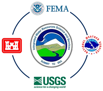
This effort will be accomplished by an interagency coalition comprised of the Federal Emergency Management Agency (FEMA), U.S. Army Corps of Engineers (USACE), U.S. Geological Survey (USGS), and the National Weather Service (NWS). These agencies are currently in partnership through the group known as the Interagency Flood Risk Management (InFRM) team and this effort will be undertaken by this group. The InFRM team will reach out to state and local government organizations as well as private industry to aid in moving this monumental effort forward.
InFRM operates under the umbrella of the Integrated Water Resources Science and Services (IWRSS), a business model for interagency collaboration. IWRSS brings a consortium of United States federal agencies with complementary water resources missions together to share resources to help solve the nation's water resources issues. In 2011 several Federal agencies came together and initiated an Interagency Memorandum of Understanding to create IWRSS. IWRSS's overarching objective is to enable and demonstrate a broad, integrative national water resources information system to serve as a reliable and authoritative means for adaptive water-related planning, preparedness and response activities. The goals are to:
The members of IWRSS are the same four United States federal agencies as InFRM: FEMA, USACE, USGS, and NOAA.
Base Level Engineering is a watershed-wide engineering modeling method that leverages high resolution ground elevation, automated model building techniques, and manual model review to prepare broad and accurate flood risk information for FEMA to assess its current flood hazard inventory. Base Level Engineering prepares flood risk information with scalable engineering, allowing FEMA to both assess its current flood hazard inventory and expand the coverage and availability of flood risk information to communities and individuals interested in reviewing their potential flood risk.
Goal: Centralized and available flood hazard analysis to support floodplain management activities and development review, while increasing risk awareness for individuals.
The InFRM Flood Decision Support Toolbox (FDST) is an interactive web application which:
As hydrology remains the single largest source of uncertainty in our understanding of flood risk, the InFRM team has been performing Watershed Hydrology Assessments (WHAs) to update flood risk estimates in large, complex river basins using suites of models developed by USACE.
The InFRM WHAs are performed by an expert team of engineers and scientists from multiple federal agencies using the latest advances in hydrologic science and technology. WHAs examine the hydrology across the entire basin, reviewing non-stationary influences, such as regulation, land use changes, and climate variation, to ensure all variables affecting flood risk in the watersheds are considered. The multi-layered analysis of the WHAs employs a range of hydrologic methods, including rainfall runoff modeling, statistical hydrology, period-of-record simulations, and reservoir analyses, and then compares the results of those methods to previous studies and to one another.
The goal of the WHAs is to produce consistent 1% annual chance (100-yr) and other frequency flows across the river basin, based on all available hydrologic information. The final recommendations of the WHAs are formulated through a rigorous review process which includes technical investigations, external peer reviews, stakeholder input, and collaboration between all of the InFRM subject matter experts.
River basins within the region are selected for hydrology assessments based on watersheds where USACE already has sufficiently detailed modeling products available as a starting point for the assessments and where FEMA had future floodplain mapping activities scheduled.
InFRM WHAs have been completed for the following river basins in FEMA Region 6:
The final reports and appendices for these studies can be downloaded from the PRODUCTS section.
InFRM WHAs are currently underway for the following river basins:
Additional basins will be added to the program as funding allows.
As a result of the level of investment, analyses, and collaboration that go into the WHAs, their results are recommended as the best available estimate of flood risk for the studied streams in the river basin, and they provide suggestions for areas where the current flood hazard information may need to be updated. The results from the WHAs can also be used to plan new infrastructure and safely locate new neighborhoods and other urban development. Furthermore, the models and data used to produce these flood risk estimates are available upon request, at no charge, to communities, local stakeholders, and architecture engineering firms.
For more information from any of these studies, please contact us.
On September 27 of 2018, NOAA's Hydrometeorological Design Studies Center released a new study called Atlas 14 Volume 11: Precipitation Frequency for Texas. The updated precipitation estimates supersede those currently available for Texas from the 1960s and 1970s. Atlas 14 data help state and local communities prepare for potential flooding and minimize weather's impacts on lives and livelihoods. Precipitation frequency estimates are used by engineers and planners to bring knowledge of flood hazards into land use and development decisions, including managing and designing stormwater infrastructure. Estimates are also used in hydrologic models to delineate flood risks and manage development in floodplains for FEMA's National Flood Insurance Program. The InFRM team, led by USACE Fort Worth District, helped raise funds and manage this project to see that Texas has the same updated precipitation data as the majority of the nation. The new NOAA Atlas 14 estimates represent vastly improved data in terms of both period of record and station density, state of the art statistical techniques, and a new approach to spatial interpolation that accounts for variation in terrain.
The NOAA Atlas 14 program provides: