Flood Map Library Development
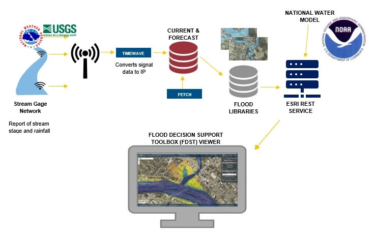
Flood inundation map libraries at USGS streamgaging stations and NWS National Water Prediction Service (NWPS) forecast points will be built using existing engineering-scale or FEMA base level engineering-scale specifications. The Hydrologic Engineering Center's (HEC) River Analysis System (RAS) will be the primary numerical modeling tool employed to prepare the inundation mapping products. HEC-RAS includes the capability for steady flow analysis, unsteady flow analysis and 2-dimensional modeling. HEC-RAS is the current standard for river hydraulic modeling across the United States. A vast array of existing HEC-RAS models are available for various river systems across Texas including:
- FEMA effective models,
- USACE Corps Water Management System (CWMS) models,
- models prepared with grants and other funding sources from the State of Texas, and
- models prepared for local governments.
Additionally, the FDST will incorporate NWS river forecast models that estimate the quantity and timing of water flowing through selected stream reaches in the United States during flooding events. These forecast models:
- estimate the amount of runoff generated by precipitation and snowmelt,
- simulate the movement of floodwater as it proceeds downstream, and
- predict the flow and stage (water-surface elevation) for the stream at a given location (NWPS forecast point) throughout the forecast period (every 6 hours and 3 to 5 days out in many locations).
The following is a high-level listing of the steps that will be required for execution of this program.
- Identification of river reaches for which the flood decision support toolbox would be of benefit to emergency responders and infrastructure management professionals.
- Prioritization of the river reaches.
- Identification of available river hydraulic numerical models which could be used to develop the flood decision support toolbox.
- Identification of topographic data available for river reaches without hydraulic models.
- Scoping the development of river hydraulic numerical models for reaches that do not have quality river hydraulic numerical models.
- Calibration of river hydraulic models to field observation, when available.
- Rating the quality of each product in the flood decision support toolbox for accuracy.
- Using existing or newly developed hydraulic models to generate map libraries for the FDST.
Documentation
Potential mapping partners may download the submittal guidance to determine the modeling requirements and steps needed to generate map libraries for their area of interest. The FDST is a "living" viewer that will be continually updated with new models and improvement to the interface. As such, the mapping guidelines will also be a "living" document that will be updated with each update to the web application. Please continue to check the website for the most recent version of the guidelines.