California Oil, Gas, and Groundwater Program
Geological Context
Geology plays a large role in determining how fluids flow - or do not flow - through the subsurface system, and where water and petroleum resources are likely to be found. The characteristics of the geologic units are also important factors in salinity mapping.
Constructing Geologic Framework Models
Geologic framework models include images constructed to help scientists explore the geometry and characteristics of the subsurface. Past research has resulted in framework models covering many of the COGG study areas.
Extrapolating to Formation Maps
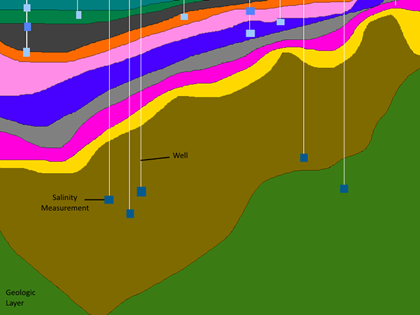
Geologic modelers transform well-specific data into interpolated 3D frameworks using techniques ranging from fairly simple layer models, such as the one shown in the first example below, to geostatistical models of lithologies (Burow and others, 2005; Faunt and others, 2009; Faunt and others, 2010).
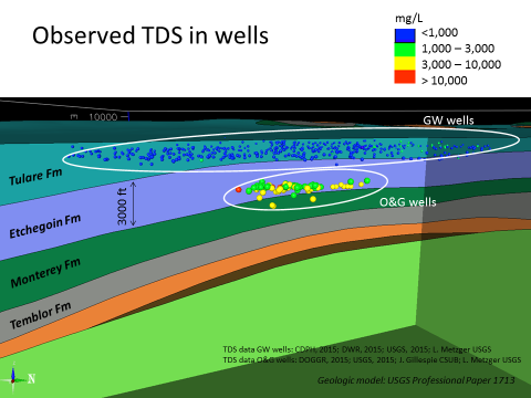
We can also use the lithology data to create 3D images of the boundaries between geologic formations. These are important because flow properties change from one formation to another. The following 3D visualization is an example of how we map formation boundaries and was constructed using data from the Fruitvale field (a detailed report and complete peer reviewed data set on Fruitvale are planned for publication).
Using the Geologic Framework Models
The COGG program uses geologic framework data and models in several ways, including:
- Designing regional monitoring networks
- Comparing salinity within and between formations
- Mapping fault locations within a study area to support interpretative analyses of whether they are serving as conduits or barriers
- Exploring flow gradients in study areas
- Identifying where oil and water wells are located in 3D in relation to the geology, including where fluid movement between these resources is most likely due to close proximity and/or relatively permeable sediments
Water management programs can also use these data to build or refine groundwater-flow models. An example of a regional scale flow model constructed using geologic framework models is the USGS Central Valley Hydrologic Model.