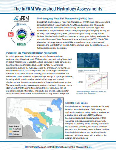
As hydrology remains the single largest source of uncertainty in our understanding of flood risk, the Interagency Flood Risk Management (InFRM) team has been performing Watershed Hydrology Assessments (WHAs) to update flood risk estimates in large, complex river basins using suites of models developed by U.S. Army Corps of Engineers (USACE).
The InFRM WHAs are performed by an expert team of engineers and scientists from multiple federal agencies using the latest advances in hydrologic science and technology. WHAs examine the hydrology across the entire basin, reviewing non-stationary influences, such as regulation, land use changes, and climate variation, to ensure all variables affecting flood risk in the watersheds are considered. The multi-layered analysis of the WHAs employs a range of hydrologic methods, including rainfall-runoff modeling, statistical hydrology, period-of-record simulations, and reservoir analyses, and then compares the results of those methods to previous studies and to one another.
The goal of the WHAs is to produce consistent 1-percent annual exceedance probability (AEP), which is also referred to as the 100-year return period, and other frequency flows across the river basin, based on all available hydrologic information. The final recommendations of the WHAs are formulated through a rigorous review process which includes technical investigations, external peer reviews, stakeholder input, and collaboration between all of the InFRM subject matter experts.
River basins within the region are selected for hydrology assessments based on watersheds where USACE already has sufficiently detailed modeling products available as a starting point for the assessments and where Federal Emergency Management Agency (FEMA) has future floodplain mapping activities scheduled.
InFRM WHAs have been completed for the following river basins in FEMA Region 6:
The final reports and appendices for these studies can be downloaded from the WHA Documents pull-down menu above.
InFRM WHAs are currently underway for the following river basins:
Additional basins will be added to the program as funding allows.
As a result of the level of investment, analyses, and collaboration that go into the WHAs, their results are recommended as the best available estimate of flood risk for the studied streams in the river basin, and they provide suggestions for areas where the current flood hazard information may need to be updated. The results from the WHAs can also be used to plan new infrastructure and safely locate new neighborhoods and other urban development. Furthermore, the models and data used to produce these flood risk estimates are available from USACE upon request at no charge.
InFRM Watershed Hydrology Assessments Factsheet
Highlights and description of the Watershed Hydrology Assessments