Groundwater Ambient Monitoring & Assessment Program Priority Basin Project
in cooperation with the California State Water Resources Board"


The Groundwater Ambient Monitoring and Assessment Program Priority Basin Project (GAMA-PBP) is a statewide, comprehensive assessment of groundwater quality designed to:
Describe and explain patterns in groundwater quality
Determine where and to what extent groundwater meets drinking water quality benchmarks
Determine how groundwater quality is changing at the basin scale
Identify the natural and human factors affecting groundwater quality
Click the "Select" tab to select layers.
Map Layers
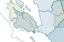
GAMA Study Areas
 | |
| STUDY AREA COLOR | |
|---|---|
| Groundwater resources used for public supply | |
| Groundwater resources used for domestic supply | |
Counties
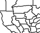 | |
| County boundary | |
Tribal Lands
 | |
| Tribal land | |
Watersheds
 | |
| Watershed boundary | |
Major Rivers
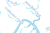 | |
| Waterbody | |
| Stream | |
| Intermittent Stream | |
Principal Aquifers
 | ||
| Blues | Unconsolidated and semiconsolidated sand and gravel aquifers | |
| Greens | Sandstone aquifers | |
| Purples | Sandstone and carbonate-rock aquifers | |
| Browns | Carbonate-rock aquifers | |
| Reds | Igneous and metamorphic-rock aquifers | |
| White | Other | |