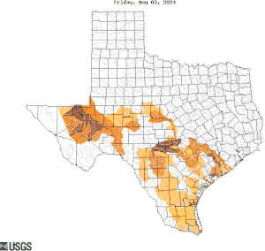
The USGS Oklahoma-Texas Water Science Center continuously monitors the status of the principal rivers, reservoirs, and selected aquifers in both states. Stations with long-term continuous record are used to compare existing streamflows, reservoir storage, and ground-water levels with normal and extreme recorded values to measure the potential for drought, or the severity of an existing drought.
Droughts do not have the same meaning or significance to all people. No generally accepted definition is adequate, nor is one practical, because drought is the result of many different factors. Three common definitions are:
A period of abnormally dry weather sufficiently prolonged for the lack of water to cause serious hydrologic imbalance in the affected area.1
A climatic excursion involving a shortage of precipitation sufficient to adversely affect crop production or range production.2
A period of below average water content in streams, reservoirs, aquifers, lakes, and soils.3
In general, when the water content in streams, reservoirs, aquifers, or soils falls below the long-term average, a pending or potential hydrologic drought may exist. The severity of a hydrologic drought is not always obvious until these water supplies are seriously depleted. The USGS network of long-term continuous record stations is important in measuring the severity of an existing or potential drought and making projections of subsequent drought conditions.
These are the primary resources for Oklahoma or Texas drought conditions and impacts.
U.S. Drought Monitor: Oklahoma
OWRB: Oklahoma Drought Monitoring

Based on about 280 USGS sites in Texas having at least 30 years of record. The data used to produce this map are provisional. Click image to view larger, interactive version.
Current surface water conditions
Streams Reservoirs and LakesBelow normal streamflow
By hydrologic unit By streamflow gaging station for the NationPlot of 7-day average streamflow compared to historic conditions
Duration GraphsInteractive map displaying multiple drought indexes
U.S. Drought ViewerData included in the USGS National Water Information System Database
All Texas Groundwater Data Real-time Data Daily Data Periodic DataActive wells with over 10 years of record, where the most recent water-level measurement is below normal (below the 24th percentile of previous levels at that well)
Below Normal Groundwater LevelsActive wells whose levels reflect climatic variability and not human influences
Climate Response NetworkAll USGS GroundwaterWatch Networks
All Well NetworksThe USGS operates over 400 rainfall monitoring sites in Texas. However, these sites are for operational purposes. Routine inspections and other quality assurance measures are not performed that would make the data suitable for archival, retrieval, or interpretive uses; therefore, rainfall data will NOT be available for longer than a 120-day display period.
Precipitation EvapotranspirationUS Rain Days/Consecutive Dry Days are computed daily, based on data from the National Weather Service.
U.S. Rain and Dry DaysBy Karl E. Winters
U.S. Geological Survey Scientific Investigations Report 2013-5113
By H.E. Thomas
U.S. Geological Survey Professional Paper 372-C
Drought text modified from Hanson, R. L., 1987, Base flow as an indication of drought occurrence. In: S, Subitzky (ed.), Selected Papers in the Hydrologic Sciences: U.S. Geological Survey Water Supply Paper 2330. pp. 115-129.
1 Huschke, R.E., ed., 1959, Glossary of meteorology: Boston, American Meteorological Society, 638 p.
2 Rosenberg, N.J., ed., 1979, Drought in the Great Plains- Research on impacts and strategies: Proceedings of the Workshop on Research in Great Plains Drought Management Strategies, University of Nebraska, Lincoln, March 26-28: Littleton, Colorado, Water Resources Publications, 225 p.
3 Yevjevich, Vujica, Hall, W.A., and Salas, J.D., eds., 1977, Drought research needs, in Proceedings of the Conference on Drought Research Needs, December 12-15, 1977: Colorado State University, Fort Collins, Colorado, 276 p.